Red Hill - Coal Creek Trail

The Red Hill is a feature that is hard to miss. It is a characteristic landmark of Cedar City that showcases the red rocks and other unique geological features that are abundant in southern Utah. The first thing that may stand out to observers are the distinct layers. What do you think caused this distinct layered structure to occur at the Red Hill?
Sedimentary Rock
There are 3 main rock types: Igneous, metamorphic, and sedimentary. Sedimentary rocks are rocks that are composed of sediment or accumulated fragments of rock and/or organic material. Sedimentary rocks form through the sedimentary process which consist of 4 main steps: weathering, erosion, deposition, and lithification. The Red Hill is composed of sedimentary rock that deposited in layers through deep geologic time as the depositional setting, environment, and climate changed many times.
- Weathering: Weathering is the process of larger rocks breaking down into smaller pieces. Eventually these smaller pieces will become the rock fragments of sediment.
- Erosion: Erosion occurs when the rock fragments are moved or transported away from their original location by wind, water, gravity, etc.
- Deposition: Eventually the rock fragments will come to rest and collect together as a body of sediment. This is known as deposition. Sediment deposition can happen in many different places and environments on Earth. Where are some places where you have seen a large collection of rock and mineral fragments?
- Lithification: Lithification simply means “to turn to stone”. For a collection of loose sediment to turn into solid rock the fragments need to be compressed and cemented together. This typically happens deep underground as pressure from the overlying layers push the rock fragments closer together and groundwater brings in mineral content that glues these pieces together.
Depositional Settings
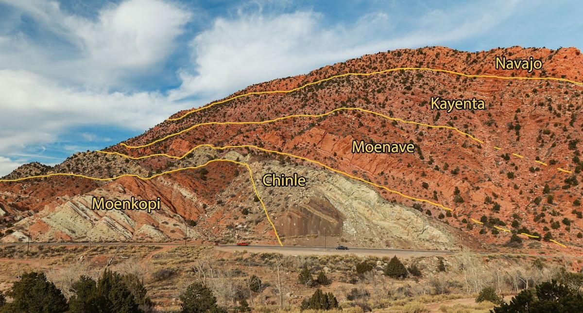
Have you ever thought about why there are unique layers with distinctive properties throughout southern Utah? Why don’t all the layers look the same? There are many factors that contribute to unique layers. However, perhaps the most important factor is that each layer was deposited in a different setting or environment. In the image below (also on the sign) you can see a few of the layers of the Red Hill with their respective names: Moenkopi Formation, Chinle Formation, Moenave Formation, Kayenta Formation, and Navajo Formation. Each of these layers was deposited in at a different time and in a different setting to give it some of the characteristics that you see.

The characteristics and depositional settings for each of the layers are:
- Navajo Formation ~185 million years old
The Navajo Formation is a thick layer of cliff forming sandstone. It is composed of mostly rounded quartz grains that are nearly identical in shape and size. This formation was deposited in a giant sand dune desert similar to parts that covered all of Utah and parts of the surrounding states. - Kayenta Formation ~ 190 million years old
The Kayenta Formation contains layers of less resistant mudstone and siltstone and more resistant layers of sandstone. This formation was deposited in a system of streams and shallow lakes. Dinosaur tracks and other vertebrate fossils can be found in the Kayenta Formation. - Moenave Formation ~200 million years old
The Moenave Formation contains layers of sandstone, siltstone, and mudstone. There is a prominent, orange, cliff-forming sandstone that is helpful in identifying this formation. This formation was deposited in a river system that contained a fairly broad floodplain. Dinosaur tracks can also be found in the Moenave Formation. - Chinle Formation ~210 million years old
The Chinle Formation contains layers of purplish mudstone that are separated by a gray layer of coarse sandstone. This formation was deposited in a large river system with a broad floodplain, similar to the Amazon River basin in South America. Petrified wood can be found through the Chinle Formation. - Moenkopi Formation ~225 million years old
The Moenkopi Formation contains siltstone, mudstone, and crystalline gypsum, with lesser amounts of sandstone. This formation was deposited along an arid coastline. The salt water would evaporate in the intertidal zone of this environment which would lead to the deposition of gypsum.
Educator Resources
Educators can download resources for teaching on the Coal Creek Trail.
